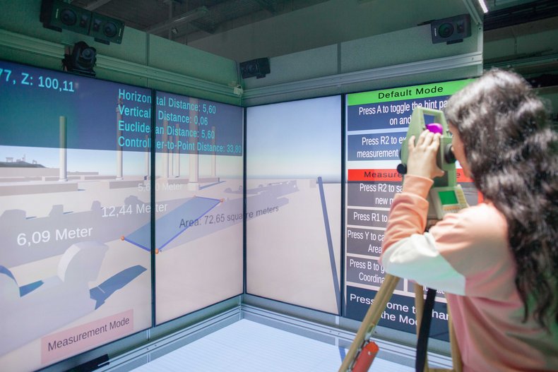
Aida Yousefi developed a functional prototype as part of her internship at i3mainz in connection with the CAVE application scenario “Virtual surveying exercise in the Geoinformatics & Surveying degree program”. She was supported by Fabian Püschel. The aim of this prototype is to simulate an (initially simple) surveying exercise as realistically as possible. This also includes the use of an actual surveying device that can be set up within the CAVE. A simple tacheometer was employed for the prototype, which can be used to aim at objects and measure distances.
By using simple gaming controllers that can be attached to the tacheometer, the movements of the surveying device can be recorded both vertically and horizontally. This means that targets in the virtual world can now be captured using a process known as raycasting. Based on the correct positioning of the actual surveying instrument in the virtual world, the raycast generates survey points in the virtual environment, the coordinates of which are determined and saved.
In addition, distances between two points, angles between two lines, and areas of selected fields can be calculated. A key component of the application is the user interface (UI), which is projected onto the upper edge of the CAVE. Here, the recorded survey data of defined areas is clearly displayed. For each survey, it is possible to start a new process at the touch of a button once the survey has been completed. This resets all previous data and the new measurement results can be saved in a separate file and exported as a CSV.
To increase user-friendliness, an information panel has been integrated to explain the various functions of the buttons and make the application intuitive to use. This enables even people with no prior technical knowledge to work quickly and efficiently with the virtual surveying application.
The application offers two modes: a standard mode and a surveying mode. This distinction makes it possible to differentiate the surveying functions from other functions, making more buttons available on the controller. This means that all functions can be activated using a specific button, which optimizes the user experience.
These technical functionalities were developed in the Unity engine and provide the basis for performing simple surveying exercises virtually without having to be physically on site. At the end of each virtual survey, the collected data can be saved and exported as a CSV file so that it is available for further analysis. The prototype has yet to be used with students.


